
Implications of Chinese Activities in the South China Sea and Benham Rise
- 1. China’s Creeping Expansion in the SCS from 1946 to 2016 Before World War II, China’s southernmost defense perimeter was Hainan Island. Before the war, China did not have a single soldier or sailor stationed in any SCS island outside of Hainan Island. In 1946, right after the war, China took over the Amphitrite Group of the Paracels and Itu Aba in the Spratlys following the defeat of the Japanese, moving China’s defense perimeter southward. China (Kuomintang) vacated Itu Aba in 1950 until 1956, when Taiwan occupied Itu Aba. In 1974, China forcibly dislodged the South Vietnamese from the Crescent Group of the Paracels. In 1987, China installed a weather radar station in Fiery Cross Reef. In 1988, China forcibly evicted Vietnam from Johnson South Reef, and seized Subi Reef from the Philippines, moving further south China’s defense perimeter in the Spratlys. In 1995, China seized Mischief Reef from the Philippines, just 125 NM from Palawan and 594 NM from Hainan. In 2012, China seized Scarborough Shoal from the Philippines, just 124 NM from Luzon. In 2013, China seized Luconia Shoals from Malaysia, just 54 NM from Sarawak’s coast. In 2014, China started island-building on rocks and submerged areas in the Spratlys to construct air and naval bases.
- 2. China’s grand design is to control the South China Sea for economic and military purposes. China wants all the fishery, oil, gas and mineral resources within the nine-dashed line. China already takes 50% of the annual fish catch in the South China Sea as more than 80% of its coastal waters are already polluted. China has the largest fishing fleet in the world, with 220,000 sea-going vessels and 2,640 long- distance ocean-going vessels. China’s fish consumption is the highest in the world considering China’s 1.4 billion population. China is the largest net importer of petroleum in the world. China wants the lion’s share of the oil and gas in the South China Sea. The Chinese estimate that the South China Sea holds 130 billion barrels of oil, and if this is correct, the South China Sea is as rich in oil as Kuwait or the United Arab Emirates. The South China Sea is also rich in methane hydrates - said to be one of the fuels of the future. China wants to secure all these methane hydrates for itself. China also wants the South China Sea as a sanctuary for its nuclear-armed submarines – free from surveillance by U.S. submarine-hunting Poseidon airplanes or U.S. nuclear attack submarines. China wants a second-strike nuclear capability, joining the ranks of the U.S. and Russia. China’s Grand Design in the South China Sea
- 3. Chinese Detection/Defense Capabilities in the South China Sea Published by the CSIS Asia Maritime Transparency Initiative | http;//amti.csis.org | Updated March 27, 2017
- 4. Combat Range of Chinese Fighter Jets in South China Sea
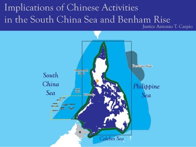
- 5. China and Philippines “Separated by Narrow Body of Water”
- 6. Scarborough Shoal – Next Flashpoint
- 7. • In the 1900 Treaty of Washington, Spain clarified that it had also relinquished to the United States “all title and claim of title, which (Spain) may have had at the time of the conclusion of the Treaty of Peace of Paris, to any and all islands belonging to the Philippine Archipelago, lying outside the lines” of the Treaty of Paris. Thus, under the 1900 Treaty of Washington, Spain ceded to the United States all territories, to which Spain had title or claim of title, lying outside the lines of the Treaty of Paris. These territories outside the lines, west of the 118 degrees east longitude, included Scarborough Shoal and the Spratlys. • *Treaty between Spain and the United States for Cession of Outlying Islands of the Philippines, signed on 7 November 1900.) 1900 Treaty of Washington between Spain & United States*
- 8. When the issue of whether Scarborough Shoal forms part of Philippine territory, Secretary Cordell Hull of the U.S. State Department stated in his Memorandum of July 27, 1938 to Harry Woodring, Secretary of War: Because of the absence of other claims, the shoal should be regarded as included among the islands ceded to the United States by the American-Spanish Treaty of November 7, 1900*… In the absence of evidence of a superior claim to Scarborough Shoal by any other government, the Department of State would interpose no objection to the proposal of the Commonwealth Government to study the possibilities of the shoal as an aid to air and ocean navigation. *Treaty of Washington; boldfacing supplied. Source: A CNA Occasional Paper, Philippine Claims in the South China Sea: A Legal Analysis, Mark E. Rosen, JD, LLM [citing François-Xavier Bonnet, The Geopolitics of Scarborough Shoal, available at www.irasec.com.] (2014) In 1938 the U.S. Had Already Determined Scarborough Shoal Is Part of Philippine Territory
- 9. 1899 “Islas Filipinas, Mapa General Observatorio de Manila.” Published in 1899 in Washington, D.C. by the U.S. Coast and Geodetic Survey.
- 10. The U.S. has officially recognized that territories Spain ceded to the U.S. under the 1900 Treaty of Washington are covered by the MDT. On 6 January 1979, U.S. Secretary of State Cyrus Vance officially wrote to Philippine Foreign Minister Carlos P. Romulo: “Metropolitan territory of the Philippines” means all the land areas and all adjacent waters subject to the sovereignty of the Republic of the Philippines, in accordance with international law, lying within the area delineated in the Treaty of Paris of December 10, 1898, and in the Treaty of Washington of November 7, 1900, and subsequently amended in the Treaty of the United States and Great Britain on January 2, 1930.” Thus, Scarborough Shoal is part of Philippine territory and is covered by the MDT, as expressly recognized by the U.S. Government. U.S. Recognized Scarborough Shoal Is Covered by MDT
- 11. The Philippine Navy issued a Notice to Mariners on 18 September 1981 warning mariners that the U.S. Navy would undertake gunnery and bombing exercises in Scarborough Shoal. Source: Bajo de Masinloc, Maps and Documents, U.P. Institute for Maritime Affairs and Law of the Sea/NAMRIA, 2014 Bombing and gunnery exercise using live ammunition have taken place at 15 degrees 07 minutes North, 117 degrees 46 minutes East within 20 mile radius. The exercises are conducted more or less on a daily basis and likely to continue indefinitely. Philippine Navy Notice to Mariners in September 1981
- 12. Bureau of Coast and Geodetic Survey, Notice to Mariners, February 24, 1983 Source: Bajo de Masinloc, Maps and Documents, U.P. Institute for Maritime Affairs and Law of the Sea/NAMRIA, 2014. The Bureau of Coast and Geodetic Survey is now part of NAMRIA. The missile firing ranges are bound as follows: Vessels may be requested to alter course within the above areas due to firing operations and are requested to monitor VHF Channel 16, 500 KHZ or other appropriate marine broadcast frequencies for details of firing schedules before entering above areas. The Bureau of Coast and Geodetic Survey announces the following navigational warnings to all mariners and others concerned in surface navigation
- 13. Scarborough Shoal and the North Korean Nuclear Crisis Scarborough Shoal
- 14. Benham Rise Benham Rise
- 15. Three Areas of Benham Rise
- 16. Benham Rise has three areas. 1. The area that forms part of the EEZ of the Philippines. There is no other claimant to this area. This area is not disputed. 2. The area that forms part of the ECS of the Philippines. There is no other claimant to this area. The United Nations Commission on the Limits of the Continental Shelf has approved the Philippine submission that this area forms part of the ECS of the Philippines. This area is not disputed. 3. The area that forms part of the High Seas beyond the ECS of the Philippines. In this area all the living and non-living resources form part of the global commons. Legal Status of Benham Rise
- 17. 1. The area is 11.4 million hectares (114,000 square kilometers); 2. The Philippines has exclusive sovereign rights to all the living and non- living resources - all the fish, oil, gas and mineral resources; 3. The Philippines has exclusive jurisdiction to erect artificial structures; 4. There is freedom of navigation; 5. Not Philippine territory under international law. Benham Rise as EEZ Benham Rise as ECS 1. The area is 13 million hectares (130,000 square kilometers); 2. The Philippines has exclusive sovereign rights to all the oil, gas and mineral resources, as well as the sedentary species; the fish belong to all mankind; 3. The Philippines has exclusive jurisdiction to erect artificial structures; 4. There is freedom of navigation; 5. Not Philippine territory under international law.
- 18. Maritime Zones under UNCLOS • Territorial sea: 12 NM from baselines; like land territory except there is right of innocent passage for foreign ships. • Contiguous Zone: 12 NM from the outer limit of 12 NM territorial sea; limited jurisdiction for immigration, fiscal, customs, and sanitation purposes. • Exclusive Economic Zone or EEZ: 200 NM measured from the baselines or 188 NM measured from the outer limit of the 12 NM territorial sea; specific sovereign rights and jurisdiction only within the 188 NM area. The EEZ is a legal concept based on distance from the baselines and does not depend on the geomorphology of the continental shelf. • Extended Continental Shelf or (ECS): the outer limits of a coastal state’s continental shelf beyond 200 NM; not exceeding 150 NM measured from the outer limit of the EEZ, or if there is a drop to a 2,500 meter isobath before the 150 NM limit, the ECS shall not exceed 100 NM from such 2,500 meter isobath; living resources belong to all mankind, while non-living resources and sedentary species belong to the adjacent coastal state. The ECS is a geomorphological concept starting from the outer limit of the EEZ at 200 NM from the baselines. • High seas: beyond the EEZ; living resources belong to all mankind; in the ECS, non-living resources and sedentary species belong to the adjacent coastal state. • “The high seas are open to all states, whether coastal or land-locked. Freedom of the high seas ... comprises, inter alia, ... freedom of fishing” (Article 87, UNCLOS). • “No state may validly purport to subject any part of the high seas to its sovereignty” (Article 89, UNCLOS). • The Area: beyond the ECS; all the living and non- living resources belong to all mankind. The Area is administered by the International Seabed Authority (ISA), a creation of UNCLOS. Member-states wishing to explore and exploit the seabed in the Area must secure a permit from the ISA.
- 19. 1. Under international law and UNCLOS, the territory of a state comprises its land territory, territorial sea and territorial airspace. The EEZ and ECS of a state do not form part of its territory because the EEZ and ECS are not subject to sovereignty but only to sovereign rights and jurisdiction. Thus, under international law, Benham Rise, whether as part of Philippine EEZ or ECS, is not Philippine territory. 2. Under the Philippine Constitution, which is national or domestic law, Philippine “national territory” is defined to include submarine areas over which the Philippine exercises “sovereignty or jurisdiction.” Under UNCLOS, the Philippine has jurisdiction to erect artificial structures, among others, in its EEZ and ECS. Thus, for purposes of national or domestic law, Philippine EEZ and ECS forms part of its “national territory.” This means that the Philippine Government, and its officials, must protect Philippine EEZ and ECS just like Philippine “national territory,” to the extent not incompatible with international law. 3. The Constitution mandates that the “State shall protect the nation’s marine wealth in its xxx exclusive economic zone.” This means that the Philippine Navy and Coast Guard must patrol Philippine EEZ to prevent not only poaching, but also more importantly to prevent encroachment by other states on Philippine EEZ. International Law vs. National Law
- 20. 1. The right of innocent passage applies to the territorial sea; the freedom of navigation applies to the EEZ, ECS, and the rest of the High Seas. 2. The right of innocent passage does not include the right to conduct military activities in the territorial sea; innocent passage must be “continuous and expeditious.” 3. Freedom of navigation includes the freedom to conduct military activities in the EEZ. It also includes the freedom to conduct depth soundings, temperature and salinity analysis to chart navigational passages for surface and submerged vessels. China is among some 27 countries that hold the minority view that in the EEZ there is no freedom to conduct military activities. The U.S. and almost all the world naval powers hold that there is freedom to conduct military activities in the EEZ. Right of Innocent Passage vs. Freedom of Navigation
- 21. • Only the area of Benham Rise that forms part of Philippine EEZ can be considered a secure food source for the Philippines. In this area the Philippine has the exclusive right to exploit all the fish, and can prevent other countries from fishing in this area. The Philippines, however, has to conduct regular patrols in this area to prevent poaching by foreign fishermen. • In the area of Benham rise that forms part of Philippine ECS, there is freedom of fishing for all countries. Countries with huge fishing fleets, like China which has the largest fishing fleet in the world, can fish in this area of Benham Rise. Filipino fishermen can hardly compete with fishermen from these countries. Thus, this area cannot be a secure food source for the Philippines. Benham Rise as Food Source
No comments:
Post a Comment